This page was saved for posterity, due to the fact I felt it had a lot of value with the details of Lake District walks. I have tried to save as much as I could and will continue to patch it up over coming weeks with the help of the internet archive. Thanks for stopping by.
Lake District Walks
The Lake district walks that are written about in our free walks guides are separated into their own pages for ease of use. Simply click the links below for more information on each walk including ratings for danger, and ease of access etc. If you would feel that the information in the walks guide is outdated, then feel free to send any changes. Amendments will be added as notes and you will receive the credit on the note.
The walks are shown in the table underneath the map of Cumbria below.
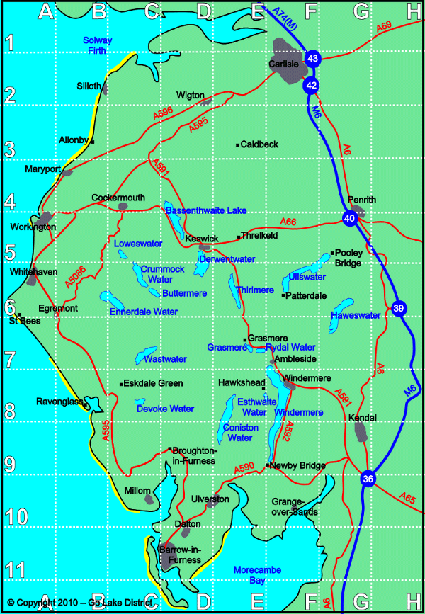
Please click on the walk names shown below to see the individual walk details:
W & P = Wheelchair and Pram possibility for the whole or part of the walk.
OS Map = The Ordnance Survey map you will need for the walk.
| Map
Ref |
OS
Map |
Walk Name | Difficulty | Duration | W & P |
| A6 | OL303 | Coming Soon: St Bees Head | |||
| B4 | OL4 | Coming Soon: Maryport | |||
| B8 | OL6 | Muncaster Fell |
|
3 hours | Part |
| B8 | OL6 | Ravenglass Coast |
|
2 hours | Part |
| C5 | OL4 | Loweswater |
|
2 hours | Part |
| C6 | OL4 | Rannerdale Knotts |
|
2 hours | No |
| C6 | OL4 | Crummock Water & Lanthwaite Wood |
|
1 hr 30 m | Part |
| D4 | OL4 | Binsey |
|
1 hr 45 m | No |
| D5 | OL4 | Barrow (Braithwaite) |
|
2 hours | No |
| D5 | OL4 | Coming Soon: Dodd Wood, Bassenthwaite Lake | |||
| D5 | OL4 | Seat How, Whinlatter Forest |
|
2.5 hours | See Note |
| D5 | OL4 | Coming Soon: Latrigg | |||
| D5 | OL4 | Coming Soon: Sale Fell, Bassenthwaite Lake | |||
| D5 | OL4 | Coming Soon: Walla Crag | |||
| D6 | OL4 | Watendlath from Surprise View |
|
2 hours | Part |
| D6 | OL4 | Coming Soon: Atmosphere of Haystacks | |||
| D6 | OL4 | Catbells and the Dale Head Horseshoe |
|
5 h 30 m | No |
| D7 | OL6 | Scafell Pike |
|
6 hours | No |
| E5 | OL5 | Blencathra |
|
3 hr 30m | No |
| E6 | OL5 | Thirlmere and Harrop Tarn |
|
1 h 30 m | Part |
| E6 | OL5 | Coming Soon: Helvellyn | |||
| E7 | OL7 | Coming Soon: Rydal Water | |||
| E7 | OL7 | Coming Soon: Grasmere and Alcock Tarn | |||
| E8 | OL6 | Coming Soon: Tarn Hows | |||
| E8 | OL6 | Coming Soon: Coniston Old Man | |||
| F10 | OL7 | Coming Soon: Arnside | |||
| F6 | OL5 | Coming Soon: Brotherswater | |||
| F6 | OL5 | Sheffield Pike, Ullswater |
|
2 hr 45m | No |
| F7 | OL7 | Brockhole to Ambleside |
|
2 hours | No |
| F7 | OL7 | Coming Soon: Fairfield Horseshoe | |||
| F8 | OL7 | Latterbarrow (Windermere) |
|
2.5 hours | See Note |
| G5 | OL5 | Coming Soon: Heughscar Hill, Ullswater |
Ordinate Survey Maps for Sale
When this website first started, ordinate survey maps were sold as a way to make a small income to help with the upkeep of the website and hosting costs etc. We no longer sell the maps, but link to Amazon who do. For full disclosure – we link to them via affiliate links, so will get a few pennies from each sale through our links. If you don’t wish to help us in this way, then by all means don’t click the links. But any help is appreciated.